Showing posts with label Lake Huron Watershed. Show all posts

Tuesday, September 2, 2014

Paying it Forward with the Kirtland's Warbler

When it comes to nature, how can we pay it forward? You know the concept: someone does a good deed for you, or pays off your debt, and you reciprocate by extending your generosity and good will to the next person in line. But hasn't nature also done us many a good deed? And don't we all have a debt to the environment, for at least clean air and water, and a whole lot more?  If you are looking to pay any of that forward, you might help out a small yellow bird in the middle of Michigan, like I did in early June.

The Kirtland's Warbler appreciates a very particular ecosystem favored by few: small scrubby areas with sandy or rocky soils. It spends the winter in dense shrubbery on a few underdeveloped islands in the Bahamas, and in the spring it migrates to the mostly flat jack pine forests between Grayling and Mio in central Michigan. The song bird likes to breed only in stands of young jack pines mixed with oak and cherry. This niche behavior was almost the undoing of this yellow-breasted bird with the bright song.

Historically, before loggers and settlers pushed into the northern Great Lakes, the Kirtland's Warbler had plenty of new growth areas to choose from for its summer home.  Fires regularly burned across the sandy outwash plains left from the glaciers. Jack pine, whose cones only release their seeds after being exposed to the high heat of a fire, is the pioneer species of these ravaged areas. The Kirtland's would skip around Michigan, Wisconsin and Ontario to build their nest on the sand amongst the new growth forests.

However, following the clear-cut logging of the north woods, settlers moved in, roads and towns were built, and forest fires became a scourge on the human inhabited land.  Smokey the Bear moved in too, and fire suppression and a quick response to any blaze became the celebrated norm. Especially in areas not well suited to farming, like the plains and low hills stretching back from the Au Sable River, a mature forest grew up to offer sites for the "up north" cabin. While good news for vacationers, hunters and anglers, the Kirtland's Warbler was out of a home.

The Endangered Species Act was passed in 1973, part of the great awakening of environmental policy, and it came just in time for the Kirtland's Warbler.  In 1971, the third census of the rare bird had found only 201 singing male birds, a 60 percent drop in 10 years. The new federal legislation gave formal recognition to the Kirtland's Warbler Recovery Team--a group of government, scientific, and environmental organizations--and gave them the legal authority and financial resources to work to prevent the loss of the species. Decades of research and effort have paid off, and the species has recovered. The censuses in both 2012 and 2013 have counted more than 2,000 singing males.

People -- scientists, birdwatchers, government wildlife workers, donors, and other enthusiasts of nature--have saved the Kirtland's Warbler, at least for the time being. Two intensive efforts have made the difference. First, the US Forest Service and the Michigan Department of Natural Resources (DNR) actively manages public lands to create appropriate breeding habitat.  Research, trial and error, and careful observation led scientists to understand that the Warbler needs large areas of young jack pine forests, mixed with other small trees and including hidden openings. Foresters have logged, cleared, or burned--and then re-planted-- sandy soil areas in both the lower and upper peninsulas of Michigan to replicate the natural landscape that existed before fires were prevented.

Secondly, cowbirds have been controlled in the breeding area. Brown-headed cowbirds lay their eggs in the nests of other birds, a strategy that evolved as the birds followed bison herds in the Great Plains.  However, plowed fields and animal agriculture brought the cowbirds to the Great Lakes and in northern Michigan they found the Kirtland's Warblers' nests an easy target. Now, the invasive cowbirds are trapped and warbler eggs can hatch and the young grow up without the competition of the larger cowbirds.

A mutually beneficial relationship exists between people and the Kirtland's Warbler, or KW as many call it. The bird now depends on people to maintain its summer home.  And people are eager to see this bird that nests in a very particular place in the Great Lakes ecosystem. They come from throughout Michigan, the United States, and the world in the early summer to discover for themselves this bird with the yellow breast and the lyrical song.  And a passionate number return year after year to see, to hear, to count, to study, and to save this bird.  Why?

I have had the chance three times to go into the field with these people whose connection to nature comes through a rare and beautiful bird. Some appreciate the scientific challenge of learning all about one unique species; others find through the bird a special connection to a Michigan place of pine trees and cold-water rivers; and many are serious birders, and they travel to north central Michigan in hopes of adding a KW to their life list of birds observed. I take any excuse to get out.

A "Big" Day.  Most recently I ventured up a sandy road east of Grayling with the accomplished birder Greg Miller and several other friends--new and old--of the Kirtland's Warber.  Greg was one of the subjects of the book and movie "The Big Year" about a quest to see more than 700 species of birds in the US in one year. He is one of the premier birders in the world, and has a long list of birds to choose as favorites, but the Kirtland's holds a special place for him.  His father brought him to the Grayling area when he was an eleven year-old boy, and the experience of finding the rare KW set him on the passionate pursuit that now defines his life.

Several decades later, the day was cool and breezy as Greg Miller accompanied a small group of experienced and novice birders scouting through jack pines not much taller than we were.  We could hear, but not see, several males staking out their territory.  The small, closely spaced pine trees gave our outing the feel of a Christmas tree hunt, though without the snow, and we could not see far into the dense growth. We stayed on the two-track, as we did not want to disturb the Kirtland's Warbler, nor inadvertently step on its nest, on the ground amidst the vegetation.

It was tantalizing. We alternately kneeled and stood on tip-toe, leaning from left to right, all in an attempt to get a clear view of the small bird flitting and singing among the young pine trees. Nothing,  and then not even a song.  We moved on, stopping and searching several times without a successful sighting.  Finally, we got a view of the bright yellow breast of a singing male amongst the shrubbery, and fellow bird-watchers almost elbowed in for a view. Then, one of the proud birds popped up to a dead tree branch, perched, and tilted up his head to warble. Cameras clicked, birders old and new sighed appreciatively, and we were transformed.
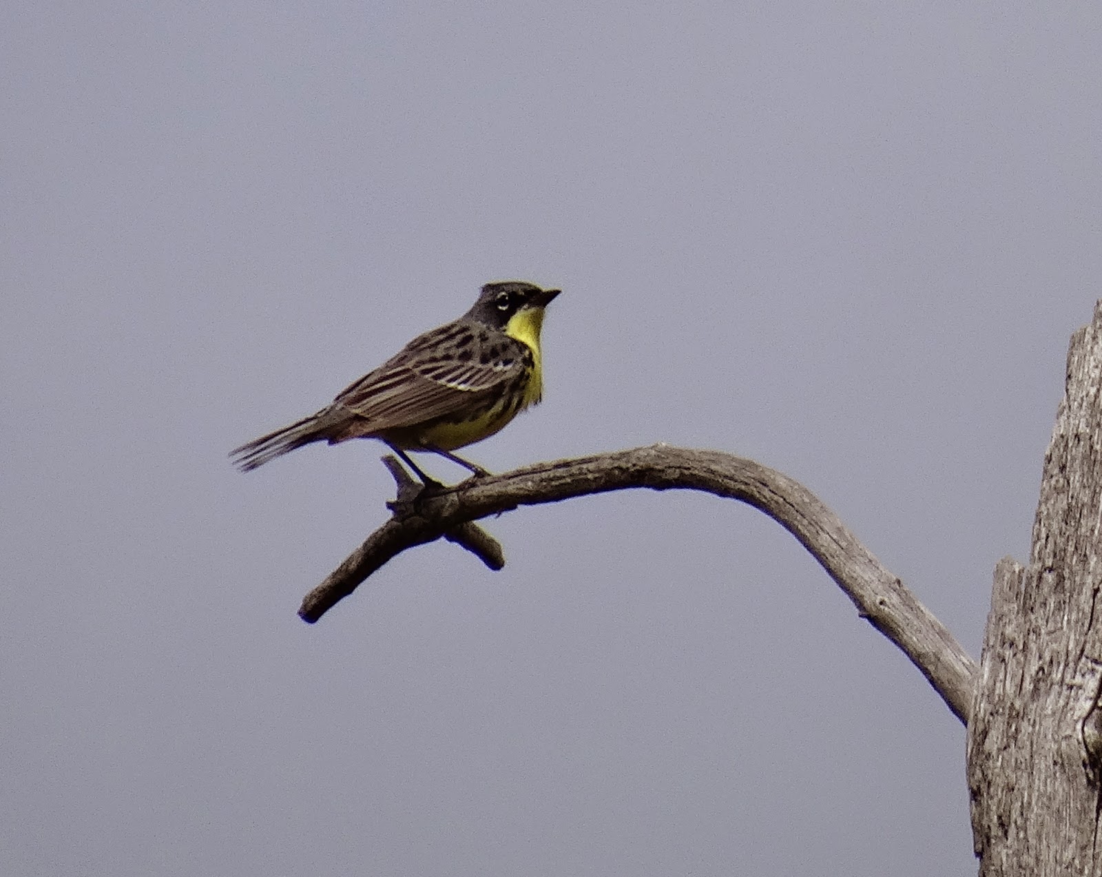


A Conservation-Reliant Species. The experience of seeing a bird for the first time in the wild is always special, but this achievement came from more than just our skill, the guidance of an expert birder, or luck. The landscape of the breeding Kirtland's Warbler exists only because of the concentrated, sustained, and scientifically-informed efforts of many people and agencies. Its winter home, in the Bahamas, has only recently been pinpointed, thanks to the efforts of The Nature Conservancy.  In both places, locals have been engaged and educated to appreciate the rarity of this bird.

The Kirtland's Warbler story is one of success, and now the scientists who have carefully studied, and the conservationists who have tended, the species are turning their attention to create natural conditions that will favor the sustained livelihood of the bird.  They also are working on building the organization and financial stability to ensure the KW will not have to rely on annual appropriations from Washington and elsewhere. The future certainly looks better than the past, but ongoing stewardship will be required.

The fate of the Kirtland's Warbler depends on humans to maintain a proper habitat, and to control competitive cowbirds. If these efforts ceased today, the population would likely again decline.  It is now what the experts call a "conservation-reliant" species.  Humans were responsible for the demise of the Kirtland's Warbler; now we are responsible to be stewards of the places the bird calls home.

The Passenger Pigeon.  The history of our relationship with nature can be measured in how we treat birds. As the Great Lakes were settled, humans observed flocks of passenger pigeons that numbered in the tens of millions. These social birds nested in the nut-rich hardwood forests that covered much of Michigan and surrounding areas; they were tasty to eat and easy to hunt, and they were no match for the technological prowess of humanity. In the 19th century, the passenger pigeon went from symbol of the abundance of nature to the victim of unchecked human consumption. In 1914, the last passenger pigeon died in a zoo in Ohio.

Sadly, the relationship between humans and birds has too often followed the path of ignorance and greed. However, in the hundred years since the demise of the passenger pigeon, Americans have redefined their relationship with birds and nature. The death of Martha, the last passenger pigeon, may have sparked the first widespread recognition that the actions of people could lead to the extinction of a species and the collapse of natural systems. It came as the work of early naturalists like John James Audubon was translated into the active conservation movement that Teddy Roosevelt had championed.  In 1918, the Migratory Bird Act was passed, and in subsequent years, wildlife management became the scientific task of federal and state governments; land was set aside and hunting was regulated. The Endangered Species Act, passed in 1973, was the policy culmination of this conservation ethic.

The story of the Kirtland's Warbler reminds us that human interaction with nature does not always result in extinction and loss. Rather, the resurgence of this small yellow bird demonstrates what we can achieve with the knowledge gained from science and the conservation efforts of both public agencies and private actors. Human actions have resulted in changed landscapes in most of the world; in one area of northern Michigan, we have cared for the landscape in a way to not only benefit us, but to also to preserve a home for one of our natural neighbors. 


 To Learn More visit these sites
The Kirtland's Warbler Initiative - the effort to build ongoing support for the species
The Kirtland's Warbler Breeding Range Conservation Plan - a recently released draft from the Michigan Department of Natural Resources
Winter Habitat (video) in the Bahamas has been the subject of study by The Nature Conservancy
Greg Miller's thoughts on the Kirtland's Warbler
To visit and see the Kirtland's Warbler, you can go on an Audobon Society Tour.

Thanks to Anna Owens for supporting my enthusiasm for birds, and for taking the photos that documented this wonderful outing.


Saturday, May 17, 2014

Wind Power from the Thumb

On the same day the United Nation's issued another report detailing the dangers of climate change, I visited one of the many places in Michigan where people are trying to figure out how to generate electricity while avoiding damage to our environment. I found no panacea, but came away hopeful.  As with many challenges we face, the solution will likely come from smart people working through the complexities of science, policy, and nature.

The Thumb of Michigan, a broad peninsula of flat land that defines half of Saginaw Bay, is one of the windier places in the Great Lakes.  The difference in temperature between the sun-warmed land and the relatively cool waters of Lake Huron, as well as the weather systems that march across the continent, create frequent, strong, and relatively constant wind flows.  In 2006, DTE Energy began an effort to take advantage of this energy resource.  Now, DTE and several private entrepreneurs have changed the agricultural landscape of Huron County with almost 300 wind turbines.

Driving around the Thumb outside Bad Axe and Cass City on a spring day, almost every view includes tri-bladed towers as tall as cellphone towers.  They populate the horizon above the tan and white fields recovering from a long winter.  They peek out from behind a rural scene of farms and silos.  A few smaller ones stand next to a schoolyard demonstrating their potential. From a distance, the post and three arms on a calm day become part of the gray view of bare trees.   Do they belong here?  Are new windmills the modern tools that have always been part of a working, agricultural landscape? Are they a hazard to wildlife?  The view of things to come?

The Clean, Renewable and Efficient Energy Act, passed in 2008 by the Michigan Legislature, spurred DTE to build windmills in the Thumb, and elsewhere in the State. Consumers Energy is also investing in wind energy. The state-wide policy requires utilities to produce 10 percent of their energy from renewable resources by 2015, and in Michigan, where the sun is not so strong, wind energy is currently the easiest and most affordable way to generate electricity without using up natural resources, without polluting air or water, and without releasing more carbon dioxide into the warming atmosphere.  The legislation, Act 295, has created a boom in windmill installations, along with the appearance of a few solar energy panels, experiments in the use of biomass fuels, more burning of methane from landfills, and some new efforts to catch the energy in flowing water and waves.

At the end of 2013, almost seven percent of the energy production in Michigan came from renewable sources, and estimates are that the 10 percent goal will be met in the coming year. DTE Energy got a jump start by buying wind power from several private companies (the legislation requires that half of a utility's energy be purchased from a third party) and by building five windmill parks, one in Gratiot County and four in the Thumb.  DTE now gets 9.5 percent of its power from renewable sources and is on track to reach its 10 percent target in the very near future.

While wind is perhaps one of the oldest and most elemental power sources, there was nothing low-tech on display when I had the opportunity to tour DTE's facilities in the Thumb.  Standing in the Cass City command center, one looks at spatial information systems, big screen computer monitors, and digital read-outs that give real time data on the operations of 300 windmills.  Going out in the field, you learn about the innovation in materials that allow for lightweight blades and the aircraft technology that controls the pitch of the blades in response to the force and direction of the wind.  The construction of these high tech machines has added $750 million to the local property tax base.  Engineers are onsite or on-call and there is one technician employed to maintain every 10 windmills.

Birds and Bats don't necessarily appreciate wind energy as much as green policy makers, but engineers certainly have considered wildlife in the design and location of wind parks.  The high towers and the spinning blades, the tips of which travel at speeds in excess of 100 miles per hour, can kill creatures that come too close, and research shows that each mono-pole windmill will kill three to eight birds annually (the open lattice towers like on old farm windmills are much more dangerous).  Nationally, this adds up to several hundred thousand bird deaths, a number that is small in comparison to the millions of birds killed each year by vehicles, building, and domestic and feral cats. (The analysis, and debate, over the impact of windmills on wildlife is extensive; read this wikipedia entry for a thorough overview; also read this scientific paper from 2013).

More than the design of windmills, the biggest cause of concern is the location of tall towers and rotating blades in areas with high concentrations of birds.  Some of the earliest wind parks in California were unfortunately located in the path of migratory birds and in geographies favored by hawks and eagles.  In the Thumb, the US Fish and Wildlife Service was consulted before
development and careful attention has been paid to flyways and avian habitat.  No windmills are within three miles of the shore of Saginaw Bay where wetlands host migrating waterfowl.  Potential windmill sites have been passed over along river corridors and woods to minimize interference.  To assess the success of these siting efforts, DTE has just begun a year-long study by independent researchers to document what impact its windmills have on wildlife.  Nationally, additional research seeks to understand the relationship between windmill operation and the nocturnal flight behavior of bats.

The Greenest Energy Solution is a holy grail that underlies any discussion of energy, environment and climate change.  We all want a clean, affordable source of energy that imposes no risks to people or harm to the natural communities of which we are a part.  We have a legacy of burning coal in Michigan that has given us cheap electricity, but has also spread soot and acid rain. One of the Great Lakes environmental threats is the toxic mercury that falls from airborne coal emissions and accumulates in fish.  Natural gas is certainly cleaner to burn and has a smaller carbon footprint than coal, but its current abundance results from "fracking" which involves injecting chemical-laden water deep underground.  Nuclear power has very little impact on climate change, but we have yet to implement a solution to dispose of radioactive waste.  Solar power has become cheaper in recent years, but in Michigan, our grey weather limits its effectiveness.  No one energy source, wind power included, can offer the best or only answer to the question of how to get energy cheaply and cleanly.

Trustees of The Nature Conservancy
Complexity.  We have to embrace complexity to resolve the conundrum of producing electricity while addressing climate change. There are high-level complexities of international cooperation, government policy, and consumer behaviors. There are technological complexities that, if resolved, can offer more energy at less cost with the least impact.  There are site-specific complexities about where to locate any energy source. I saw all of these complexities at play in the Thumb, and I met engineers and technicians willing to tackle the questions and seek the best possible outcomes.

Complexity does not always seem welcome in the policy arena, or in popular media, or in cursory conversations.  Something about our mind wants a nice simple answer,  to divide the world into good versus bad, or to frame choices between black and white.  But we only have to look to nature to understand that complexity is normal. So too is diversity, and we should look for several answers to the energy and environment debate. To tackle climate change, we need to accept that we are dealing with perhaps the most complex system in nature, and perhaps the most difficult of policy decisions. From there, we need to proceed with our best thinking and our best efforts, and eschew narrow viewpoints and not over promise answers.

A windmill can be a beautiful thing, but it can also be deadly if in the wrong place. Like all human actions, efforts to provide new sources of energy can have both positive and negative outcomes.  Wind energy can, and should be, part of how we best balance our use of energy and our protection of the environment.  In Huron County, one can see the potential of wind energy to resolve some of the conflicts in climate change, but one can also see that complexity will be our companion as we move forward.


Sunday, September 9, 2012

Hiking and Biking Bois Blanc Island

There is something about being on an island: the onboard anticipation of the journey there, the defined boundaries of a shoreline, the sense of shared belonging with other castaways.  It's romantic escaping to an island, and as summer waned Anna and I spent a day marooned on Bois Blanc Island, where The Nature Conservancy (TNC) has protected over 200 acres of shoreline, swamps, inland lakes, and cedar-pine forest.  We biked, hiked, canoed, and discovered.


Islands of Life.  There are 32,000 islands in the Great Lakes, the world's largest collection of freshwater islands. "The Great Lakes islands are outstanding in terms of biological diversity.  These islands . .  include endemic species, rare habitats and critical biological functions.  They are important breeding and staging areas for colonial nesting waterbirds, harbour noteworthy assemblages of plants and animals and provide important stopover sites for migrating birds," according to a comprehensive analysis recently conducted by The Nature Conservancy and The Nature Conservancy of Canada with the support and assistance of the US Environmental Protection Agency and the Ontario Ministry of Natural Resources. The report "Islands of Life" (click here for full report) documents the great biodiversity of these islands which are of importance to two nations.

"Island biogeography" describes the unique nature of those species that evolved and exist in water-isolated places.  Certain species may be lacking and other species may be overly abundant, both conditions creating different plant-animal-environment relationships.  Some species may be unique, or endemic, to one particular island or the special environments that predominate on islands.  And of course the limited geography of an island puts at risk those species that may live in a place that cannot be replicated or its natural residents easily moved.  The introduction of alien, invasive species can be particularly devastating. All of this bring islands to the attention of conservationists.

Bois Blanc, which locals pronounce as Bob-Lo, stretches across Lake Huron on the eastern edge of the Straits of Mackinace.  It exists as an island because of the tough dolomite and limestone of which it is made.  It is part of a long run of resistant geology that arcs across northeast Lake Huron and the largest of a short run of three islands:  Mackinac, Round, and Bois Blanc.  The name in French means white wood, either a reference to the birch trees that grow on the island or perhaps to the white timber of the basswood tree used to make canoes by the native americans who were the first inhabitants of the island.

Like most visitors, we reached Bois Blanc by ferry, less than six miles from Cheboygan, riding across on a Sunday morning where the smooth, dimpled water begged for a canoe (the return trip seven hours later, with a strong side wind and bigger seas that wet the decks, revealed the dangerous variations of the Great Lakes ).  We rode our mountain bikes along the graveled road that borders the south and east sides of the island, returning waves from friendly islanders who slowed down their trucks, old cars, or ATVs in an attempt to reduce the dust that followed their passage.  A short ride brought us to the familiar green-and-white sign of the Snake Island Preserve that The Nature Conservancy has maintained since 1987.

Snake Island, a former island that low water has now connected to the larger Bois Blanc Island, is so named for the preponderance of eastern massasauga rattlesnakes that abide there.  A hot day at the end of a dry season did not leave any snakes out for easy viewing, and we were only a little disappointed not to see any.  Also missing were the dwarf lake iris that bloom earlier in the year. From a rocky shoreline, the preserve stretches inland, paralleling another long State land holding.  We followed the well maintained, if uneven, trail for less than a mile through a tangle of cedars and what would be moist wetlands in a normal year, or in springtime.

The route passes by a small beaver pond, the somewhat larger Mud Lake, and then arrives at Thompson Lake.  There are six inland lakes on Bois Blanc.  Good fortune made a canoe available to us and we were able to take a short paddle around the Lake, one half of which is deep, the other half shallow.  No docks or shoreline structures were apparent to us.  Floating along the forest-lined shallow end, we watched a beaver enter the lake, and later saw it swim nearly under our canoe.

Returning to shore, we walked back to the road again, marveling in the quiet of the island.  Later, on the return ferry, I met a local who knew the TNC trail well:  he said he makes frequent pilgrimages to a secret spot on one of the inland bodies of water to contemplate and commune.  Our lunch on the sunny, open shore of Lake Huron was also a solitary moment for us, but much different than the quiet enclosure of wood and inland pond.  We were exposed to the wind. We thought about searching for a stand of old growth trees on additional TNC land to the north of Mud Lake, but our bikes called us on to explore more of the island

Biking a landscape may be the perfect compromise between the slow, quiet passage of a hike and the speedy consumption of views from a motor vehicle.  We followed the well-groomed gravel road north and then west on the far side of the island.  There, just past the turn to Lake Mary, we followed a narrow two track through mostly State Forest.  The deep white cobbles of old shorelines forced us off our bikes several times, but we were rewarded with views through the trees to Lake Huron and Mackinac Island in the distance.  Our bikes gave us an easy return across the island and Fire Tower Road brought us back within plenty of time to catch the final ferry of the day.


Islands are special, and Bois Blanc is one to put on your list for a visit.  On the mainland, forests and farm fields can stretch on from crossroads to small town to suburb to city.  Many of these locations are unique, but often we struggle to find a sense of place. We look for a landscape feature, or a historical site, or distinctive architecture to help fix ourselves in space.  Islands, by their very definition, offer a ready made sense of place: shoreline, the boundary of land by water, and the unique residents--animal, plant, and human--are a strong statement of place.  In our busy, over-developed, under-appreciated region, our Great Lakes islands are places to be enjoyed, treasured, and saved.

To Visit:  take the ferry from Cheboygan (information and schedule here) and upon landing, head east and then north on Bob-Lo Drive until you see the TNC sign.  The trail to Thompson Lake is shortly after the sign on the left (west) side of the road.  Snake Island is another 100 yards or so on the right (east) side of the road where there is a small parking area.  Follow the old two-track to the cobble beach.

Monday, August 6, 2012

Legacies from Legacies

Where did you gain your interest in nature?  What were your first experiences in the out-of-doors?  Who first introduced you to the mysteries and joys of some special place?  These thoughts crossed my mind as I attended the dedication of a preserve addition on a Great Lakes shore on a blue-sky day in July.

Big Trout Lake is the new gem in the crown of properties The Nature Conservancy (TNC) protects along the northern shore of Lake Huron in the Les Cheneaux region of the eastern Upper Peninsula.  After several years of fundraising and effort, 722 acres of land were recently acquired to expand the existing 828 acre Carl Gerstacker Preserve at Dudley Bay.  This preserve, which TNC started to assemble in 1993, protects valuable shoreline, upland forests, and Little Trout Lake.  The new expansion contains an outstanding Aspen-Birch-Spruce-Fir forest and Big Trout Lake, a large inland body of water virtually free of development.

The rocky, island-studded, wooded north shore of Lake Huron plays a critical role in the ecological vitality of the Great Lakes (click here to see my account of an earlier visit to the area).  For many years, TNC has been working with a number of researchers from several universities to learn more about the importance of the region's shallow waters to support fish reproduction, the refueling stations for migratory birds in the spring, and the complex interactions between water quality, wetlands, near shore forests, insect life and the birds and fish who feed on them.

Jerry Jung and his daughter
Legacies of Legacies.  It is science that directs TNC's preservation of ecological hotspots like the Les Cheneaux coastal region, but what is the motivation of the donors who make it possible to protect these places?  Of course, many supporters are impressed with the science basis of TNC's efforts, and they certainly see how preserves like Gerstacker at Dudley Bay add to the quality of life and local economy of a resort region like the Les Cheneaux.  However, when donors speak about their motivations they often recall their youth and some one, and/or some place, that made them into the people they are.

Jerry Jung, a long-time supporter of TNC, and one of the donors of the Big Trout Lake expansion, spoke only briefly at the dedication of the improved preserve, but he mentioned two things.  First, he recalled his grandmother, Alma Jung; secondly, he spoke warmly about spending time with her as a child on the shore of Lake Michigan.  Significantly, he also brought with him his three children to share in the creation of this legacy of a preserve.  His mother's name will be on the dedication sign at Big Trout Lake.

The recollection of people and places seems typical of conversations with conservationists.  A vacation spot cherished for generations, a trip with a relative to an exotic locale, summer camp, and the care of interest of an aunt, grandfather, counselor, or other adult with a commitment to nature all seem to be common threads among those who work, or give, or write, or research, or otherwise conserve our natural places.  We talk of preserves as a legacy for the future, and they very much are, but they are also  embodiments of a legacy of some earlier very personal experience.

Little LaSalle Island.  After the dedication of the new addition to the Carl Gerstacker Preserve, I was fortunate to be able to visit another TNC property in the Les Cheneaux area, the 104 acre Little LaSalle Island Preserve south of Cedarville.  Accessible only by boat, this preserve too is a legacy of a legacy.    After several decades of family summers exploring the shores and bays of the Les Cheneux area, Sam Benedict made a land donation to The Nature Conservancy in 1976.

Olle Karlstrom leads an
expedition on Little
LaSalle Island
His daughter, Libby Maynard, who has served as a trustee of TNC's Michigan Chapter, recalls learning to walk there, finding beaches on other islands as a teen, and sailing a wooden L class sailboat in the sheltered waters of northern Lake Huron.  This family's attachment to place continues, and will be a perpetual legacy, thanks to the creation of this very special preserve.  As Libby's husband Olle led us across ancient and new shorelines on the island, and we clambered through and around larch-studded wetlands, we were taunted by the cries of a circling bald-eagle, who thought we were too close to a nest we never saw.


The Next Generations.  Following the publication of Richard Louv's book "Last Child in the Woods," new attention has been given to the importance of the outdoor life for children.  There are many benefits that nature provides to young people in their growth and development, but when children become adults they can make a repayment.  They volunteer, they give, they teach the next generation, or find other ways to employ their concern for and connection to nature.  Certainly the nature that is the Les Cheneaux region has benefitted from the youthful lessons of place and people that continue to work to protect the Great Lakes.

To Visit.  The Les Cheneux islands in the area of Cedarville and Hessel are a great place for a multi-day vacation or a short-term expedition (go to www.lescheneaux.net for information).  You can learn more about the Carl Gerstacker Preserve at Dudley Bay at the website of The Nature Conservancy in Michigan (click here for information and directions.)

TNC's Michigan Director Helen Taylor outlines past, present, and future plans
to protect the Les Cheneaux shoreline of Lake Huron

Monday, September 26, 2011

Searching for Sunrise in Saginaw Bay

Sunrise brings hope. The lightening of the sky, the under-cloud illuminations, and then finally the red-orange fire of the sun itself embodies opportunity reborn. I recall an unplanned bivouac in the Sierra spent underneath a space blanket, and I never appreciated more the warm sunrise that brought the ability to see, move, and feel.

The Quest. On a recent fall Saturday, Anna and I accompanied a photographer friend (Michael DL Jordan) on his quest to record a sunrise over Lake Huron and capture some views of Saginaw Bay. It was a grand adventure: an early rise, coffee in a thermos, the GPS glowing on the dash, a traffic free drive up I-75, and then the challenge of finding our way out-of-doors in the dark. We drove to the end of the dirt road at Nayanquing Point State Wildlife Area north of Linwood. Even in the pre-dawn darkness we could see that the Bay was still some distance away, so we loaded up the photo gear and walked toward the shore to get a clear shot of the sun coming up over the water.

After walking a short distance on a path through shrubs around a marsh, I felt sand underfoot and could make out a treeline that marked the shore. I knew we must be close, but as we came up a slight dune rise, where there should be beach and waves I saw nothing but marsh grasses. Well, we were in a wildlife refuge, so how natural. I could make out a pathway through the reeds and headed east; the ground got squishy and the plants grew taller. Soon my feet were in water and my head was among swaying phragmites, the despicable alien plant that has invaded the wetlands of the Great Lakes. Defeated, I squished backwards in retreat. Where was Saginaw Bay?


Saginaw Bay is the body of water between the thumb and the hand of Michigan; it is among the biggest embayments in the Great Lakes and it has played an important role in the region's logging, industrial, shipping, and agricultural history. The watershed that drains into the Bay is the largest in Michigan. It is renowned by sportsmen for the fish and waterfowl that can be found there. It contains the longest stretch of extant coastal wetlands in the Great Lakes.

Saginaw Bay is typical of several other shallow water coastal areas of the Great Lakes. These areas are biologically rich and provide important spawning grounds that are integral to the aquatic food web. Small fish, and the foods they grow on, are found in the sheltered waters along the shore where the boundary between land and water is fuzzy with the green growth of marsh grasses and aquatic plants. The fish of the Great Lakes depend on these warm-water coastal areas. Likewise, migrating waterfowl and other birds thrive in these wetlands and associated shallow waters.

Ecosystem at Risk. What makes Saginaw Bay and other near shore areas ecologically rich, also puts them at risk. The natural cycles of Great Lakes water levels may create new beaches or erode dunes in some areas. In shallow areas, a drop like the 3-4 foot decrease in Lake Huron over the last few years exposes yards of rich lake bottom. Normally, this cycle allows wetland flora and other unique plants to flourish. However, the drop in Saginaw Bay coincided with the arrival of phragmites australis, an invasive species that crowds out native plants. These reeds grow so tall and dense that they block not only an intrepid photographer from reaching the shore, but prevent birds, mammals, and other aquatic species from using these wetlands for shelter or food. On our trip, we found several areas where the delicate marsh plants common to the shoreline were being overpowered by the phragmites. This is true throughout Saginaw Bay.

Another invasive species, the quagga mussel and its cousin the zebra mussel have also brought harm to Saginaw Bay. These small, but prodigious, shellfish filter water to feed and they have made the Bay waters clearer. While this may at first seem to be a good thing, the shallow waters of the Bay warm up faster as light penetrates deeper. The warmth and the sun support algae growth; the elevated amount of phosphorous in the Bay from run-off further feeds the blooms. Now, some coastal beaches of Saginaw Bay are plagued by what is unaffectionately called "muck," the detritus from unwanted algae growth. The most common algae is cladophora, which is unsightly and collects bacteria and other pathogens; more rare is the algae spirogyra, which can turn toxic. It can all make for an unpleasant walk on the beach.

Not all Bad News. Perhaps counterintuitively, several of the factors that challenge the health of the Bay have benefitted one of its greatest assets: walleye. The shallow waters of Saginaw Bay have historically supported a vibrant walleye population, and after some years of decline and concern, the population is now thriving. One theory is that another invasive species, the round goby, provides ample food for the walleye. Gobies are a small fish that arrived in the ballast water of ships from europe and feed on quagga and zebra mussels, among other things. So appealing are the gobies that you can now buy lures for bass or walleye fishing. The Michigan Department of Natural Resources used to stock walleye in Saginaw Bay, but has not needed to for several years now. The population appears to be self-sustaining.

Mostly what the last few years have shown is that Saginaw Bay, and the flora and fauna (and humans) who live there, are part of a complex system. The challenges to the health of the Bay are not easily defined to one single problem or vector. Much of what makes the Bay special--the walleye and the waterfowl, the open water boating, and several points of public access--remain. Also, there are some wonderful swimming beaches, on the northern stretches on both sides of the Bay. Birdwatchers also know the Bay well for several great birding hotspots. Many other recreation opportunities abound.

Working Together. Perhaps the best news is that several organizations are turning their attention to Saginaw Bay and bringing resources to bear on the challenges and opportunities in the region. The Saginaw Bay Watershed Initiative Network (WIN) has worked for many years to build a sustainable community centered on the Bay and its environmental assets. The State Department of Environmental Quality has made the Bay a priority and is working with local governments, the Sagniaw Bay Watershed Partnership and others on the Saginaw Bay Coastal Initiative. Importantly, the understanding of the connections and relationships of life in Saginaw Bay are becoming better known. With a stronger science base, conservation efforts will become more effective.

Most recently, The Nature Conservancy (TNC) has become involved in Saginaw Bay as part of its Great Lakes Project. This system-wide strategy is working to protect coastal and near shore areas, reduce polluted run-off in watersheds, reconnect aquatic food webs, and fight aquatic invasive species; all these approaches are needed to restore Saginaw Bay. TNC is coordinating its effort here with two other shallow water areas: Green Bay in Wisconsin and Western Lake Erie. These three areas have very similar ecosystems and face similar challenges. What can be learned about the complex system in one place will likely apply in the others.

Sunrise for the Bay. On our search for Saginaw Bay, we retreated to the sand ridge and found a clear spot that allowed us to see water just beyond the marsh grasses and around the phragmites. Waves rippled in the distance on the morning breeze. Seagulls winged overhead and a pair of sandhill cranes croaked by in flight. The clouds on the horizon began to glow. The sky turned a pale blue. We could see egrets picking their way through the shallows in search of breakfast. Then, gloriously, the orange sun rose up from behind a cloud, the cameras clicked, and we smiled at the start of another great day on the sunrise side of the Great Lakes.


All photos (except this one) property of Michael David-Lorne Jordan/DLP. No reproduction without permission. More of Michael's beautiful work can be found in this slideshow of sustainable forestry in the Big Two Hearted River Watershed.

Click here for a map, address, and use rules for Nayanquing Point State Wildlife Refuge

Sunday, July 24, 2011

Saving A River: Paddling the Shiawassee

How do you preserve a river? Land trusts and environmental groups like The Nature Conservancy have a long and successful history of acquiring special places and protecting them through ownership, conservation easements, or real estate partnerships with public entities. This approach works well for land, but you cannot purchase a river. How then can we save a river, and other bodies of water?

For me, the question is an important one, because one river, the Shiawassee River, runs through my life. At about the age of 10 my family moved to a wooded lot above a park along the Shiawassee, and I spent my adolescence exploring the River and a tributary that flowed behind my house. I made frequent canoe trips down the Shiawassee and the skills I learned there took me on to to other rivers in Michigan and several wilderness expeditions to northern Canada. I have some strong memories of special trips on The Shiawassee with my family, friends, and then my children, and it is one of the places I return to either in mind or body to refresh my spirit. I started this blog with a post about the importance of places, and the Shiawassee River is one of the key places that connects me to the natural world. To quote the great writer Wallace Stegner, "if you don't know where you are, you don't know who you are."

"The Healthiest Warm Water River in Michigan" was what one scientist said while presenting data from a fish survey of the Shiawassee River. And indeed, the River does have a high diversity of aquatic life with not only 59 fish species, but also 12 species of freshwater mussels, and healthy populations of macroinvertebrates (i.e. bugs) as revealed by volunteer stream sampling. Unlike the spring-fed trout streams of Northern Michigan, the Shiawassee and other rivers of the Lower Peninsula are fed largely by surface run-off and thus have warmer water temperatures. Thus, the Shiawassee is appreciated for its smallmouth bass fishing.

The Shiawassee, which starts in a few small lakes and fens (a bog fed by groundwater) in Oakland and Livingston Counties, flows north to Saginaw Bay. It is in an interesting ecological zone where plant species from the south, such as the Kentucky Coffee Tree and Catalpa, overlap with northern trees like the White Pine. On one part of the River near Henderson, a signature Sycamore tree (the mascot of Indiana State) towers over one bend in the River; on the next bend a small stand of northern-dwelling Hemlock cover the banks.

On a recent canoe trip, I had several other reminders of the health of the Shiawassee: a large number and diversity of turtles sunning themselves on the shore or rocks, several different great blue herons patiently fishing, and--most dramatically--a pair of bald eagles near the Shiawassee Conservation Club. There have been increases in the number of eagles in the Great Lakes and the Shiawassee National Wildlife Refuge at the south end of Saginaw Bay. Now, they have come upstream not only on winter forays for fish in open water, but to nest.

The Shiawassee faces challenges, both from historic misuse and from some more persistent problems. Like many freshwater environments in the United States prior to the Clean Water Act, the Shiawassee struggled with an overload of poorly treated municipal sewage and industrial waste. Residential septic tanks along tributary streams also added to problems. Thanks to the investment of federal, state and local governments, major upgrades were made to the municipal wastewater treatment facilities along the Shiawassee and pollution dropped dramatically in the 1980s. The River still suffers when severe storm events cause an overflow of sewer effluent. When I look at the Shiawassee running clear, I always thank those leaders who had the wisdom to adopt, and fund, the Clean Water Act. Sadly, this keystone law is now under attack (read more here).  Infrastructure investments are still needed to put an end to sanitary sewage overflows.

The other negative legacy comes from several industrial operations that improperly disposed of wastes; in its history the Shiawassee has had fish advisories issued after spills and even one upstream stretch was a Superfund site. Fortunately, these pollution sources have been eliminated, again thanks to state and federal government. I am always amazed at the ability of rivers to cleanse themselves: the passage of time, the constant flowing of water, and the biological activities of flora and fauna can do much to restore a river. A paddle on the Shiawassee today will not reveal the problems of its past.

"We have met the enemy, and he is us," said the great philosopher Pogo, and he could be talking about the problems facing the Shiawassee today. The point sources of pollution, sewage plants and industries, have been largely cleaned up, but the River still suffers: too much sediment, too much fertilizer, and too much trash. These come mostly from how we treat the lawns in our backyards, the farm fields in our countryside, and the stormwater from our cities. So to prevent polluted run-off we need to make changes in how numerous individuals and property owners use the land that drains into the Shiawassee. This requires a broad-based and constant commitment.

As in other watersheds, several partners have come together to restore the Shiawassee: The Friends of the Shiawassee River conduct an annual clean-up, the Shiawassee Conservation District works with farmers to promote better land use practices, and The Nature Conservancy has helped provide strategic guidance and build local capacity. Recently funding from the US EPA's Great Lakes Restoration Initiative and other public and private sources has helped fund several projects to enhance the health of the Shiawassee River.

Too much water too fast may be the most intractable problem facing the Shiawassee and other rivers in the southern portions of the Great Lakes. Before settlement, much of the central area around Saginaw Bay consisted of marshes, wooded wetlands, and absorbent soils. When it rained, these areas soaked up water like a sponge and released it slowly into meandering streams that flowed to the Shiawassee. After the clearing of lumber (Michigan's White Pine boom began in the Saginaw Bay region), farmers went to work and dug ditches to provide drainage and make the area a rich agricultural resource that gave birth to Owosso and many other communities.

Today, drainage tile underlies much of the farmland and county drains carry run-off quickly to the River. This is good for farming, but creates rapid rises in the River which increase erosion, carry more sediment into and down the River, and alters habitats. When it has not rained in some time, the Shiawassee runs clear and shallow; after a storm, the flow increases sharply and the River turns brown with soil. Over time, this has made the Shiawassee a flatter, shallower stream and important fish feeding and breeding areas have been covered with silt. It also costs landowners money to continually dredge out county drains and fight erosion along their fields.

The Two-Stage Ditch may be part of a solution to the run-off challenges of the Shiawassee and other agricultural streams in the Great Lakes. Rather than the typical narrow ditch with a straight flow of water, the two-stage ditch is wide and allows a stream to curve back and forth. This allows for more habitat areas, short-term storage (and thus the slowing) of run-off, and lower maintenance costs. The Nature Conservancy has worked to design, promote and develop two-stage ditches in Indiana, Ohio, and Michigan, including one close to Owosso that was installed by the Shiawassee Conservation District. This approach not only serves the needs of farmers to drain agricultural lands, but also helps moderate the flow of rivers. It is part of the tools that will protect and restore rivers like the Shiawassee.

Can a river be preserved? Yes, but it requires not only funding for improvements like wastewater treatment plants and two stage ditches, but also policies and programs that work with landowners, farmers, and cities to reduce polluted runoff. A watershed strategy needs to coordinate the efforts of government agencies, non-profits, and private landowners to address the unique needs and circumstances of each river. And perhaps most importantly, the residents of the watershed, need to become engaged "place-holders" and advocate on behalf of the river. When we truly connect with, and hold dear, the place in which we live, then we begin to understand the connections in nature. And the key connection for a river is the one between land and water.

Canoeing on the Shiawassee is a special experience, and not only for someone who grew up on it. It is an opportunity to witness the restoration of a river. The Shiawassee is a healthy river, but only because of conscious stewardship from several players, from the federal government funding for sewage treatment plants to the volunteers who have pull out tires. Rivers have strong powers to restore themselves, but only if we work to correct past abuses and strive to prevent further damage. Paddle the Shiawassee and see the difference we can make.


How to visit. There are many great canoe spots along the Shiawassee, including the headwaters around Holly and Fenton. Further downstream, The Friends of the Shiawassee River have an excellent canoe guide that details paddling opportunities in the main stem from Byron to Parshallburg (just south of Chesaning). There is a map and a detailed guide that provides not only helpful paddling hints, but also information on the human and natural history of the Shiawassee. I most often get out on the River at Harmon Patridge Park (map here) on the north side of Owosso and paddle to Henderson Park or beyond. I also sometimes put in at Geeck Road Park near Bancroft Michigan (map here) and paddle to the dam site at Shiatown.

When to visit. The spring, early summer and fall are the best times to paddle the Shiawassee because there is more water flow. If a week or more goes by in July and August without rain, then low water levels will require the paddler to disembark and walk the canoe over and through sandbars or rock gardens. You can check the flow of the Shiawassee River at Owosso at this monitoring site run by the United States Geological Survey. A river level of 2 to 3 feet is usually sufficient; be cautious of flood events as the river becomes less predictable and overhanging trees can become hazard. My favorite time to venture forth is in the fall, when the colors of changing deciduous leaves make a trip particularly pleasurable.

(links updated 8/8/15)

Sunday, July 10, 2011

On the Shores of Lake Huron

The Nature Conservancy (TNC) has an ambitious and essential goal to ensure the Great Lakes are a sustainable, healthy, and resilient resource that provides benefits to both nature and people. Those of us who live in the region defined by Lakes Michigan, Superior, Huron, Erie and Ontario of course identify with what some have called "the North Coast." However, when do we actually experience the Great Lakes themselves? For a few of my friends, fortunate opportunity brings them onto one of the five big lakes as sailors, boaters, or fishers. But for me and many others, our Great Lakes encounters are from the land looking out. The coasts are the most accessible, attractive, biologically diverse, ecologically important--and most threatened--components of the Great Lakes ecosystem.

I reconnected with the Great Lakes this past weekend with visits to a pair of TNC preserves on Lake Huron: Grass Bay east of Cheboygan and the Carl Gerstacker Preserve at Dudley Bay east of Cedarville. As well, we stopped in at the Mackinac Bay preserve near Hessel, maintained by the Little Traverse Conservancy. These preserves are across from each other at the northwest end of Lake Huron (just east of the Straits of Mackinac).

View Lake Huron Preserves in a larger map

While all three of the preserves are important coastal habitats, they have very different features. Dudley Bay, the most easterly preserve, is a rocky shoreline of bedrock limestone backed by a pine and hardwood forest. Mackinac Bay, the most northern of the three, is a large wetland marsh interspersed with a shallow area of Lake Huron. Grass Bay, to the south, is a sandy coastal zone where changing lake levels have left an interesting ecological heritage of various wetlands, open dune areas, and shoreline forests. Visiting all three in a day illustrates the importance of preserving the diverse coastal areas of the Great Lakes.

Dudley Bay, home to the Carl A. Gerstacker Preserve, is where we started our day with a hike on the several miles of trail The Nature Conservany maintains. The trails lead in from the coast through a spruce, white pine, and hardwood forest to the delicate Little Trout Lake. Our inland lakes are their own little treasures, and this protected lake is free from all development, a rarity in Michigan. The "Blue" Trail crosses several small hills that offer an outlook on the water; we observed a cruising family of mergansers . After our hike, we went for a walk on the shore of Lake Huron, starting out on a classic sand beach and then progressing to a rocky shoreline which harbored interesting plants and lichens. The proximite shallow water areas and woods support a smorgasbord of insect food options for migratory birds in the spring, who make landfall here after crossing Lake Huron.

The establishment of this preserve began in 1993 and has been expanded over the years to more than 900 acres. A large 1996 acquisition of coastline and woods was made possible the Dow Chemical Company Foundation, the Herbert H. & Grace A. Dow Foundation and the Rollin M. Gerstacker Foundation. At that time, the preserve was named the Carl A. Gerstacker Preserve, in honor of the former chairman of the board of Dow Chemical and a founding member of The Nature Conservancy's Michigan board of trustees. He was but the first of many corporate and philanthropic leaders who were committed to preserving the most precious places in the Great Lakes.

Mackinac Bay Preserve was our destination after our morning hike. Just west of Hessel, the observation deck, interpretive signs, benches and a picnic table made a great spot for our lunch. Here one has a very different view than the rocky outcroppings and captured sand beaches of Dudley Bay. However, these 22 acres of well vegetated wetlands, tucked into the Les Cheneaux Islands, is critical habitat for threatened amphibians, migrating birds, spawning fish, and (as we saw) an active beaver. This preserve, a 1994 project of Little Traverse Conservancy was made possible by the active cooperation of Little Traverse and The Nature Conservancy with help from the local Les Cheneaux Community Foundation.

While The Nature Conservancy maintains several valuable preserves, it has saved more of the Great Lakes through cooperation with local land trusts, state land holders, and federal agencies. There is a long legacy of TNC using its scientific knowledge, real estate acumen, and access to funding to quickly acquire threatened and critical sites and work with other partners to permanently protect and manage the site. Since the early 1990s, The Nature Conservancy has worked with local partners to study and sustain the Les Cheneaux Island region. This has meant not only identifying and protecting key sites and critical habitat sites, but also helping to support a local community that sees the environment as an economic asset. Now, this area brings in a significant number of visitors interested in birdwatching, kayaking, fishing, hunting and other sustainable activities (learn more here).

Grass Bay Preserve, was our last stop of the day. Crossing the Mackinac Bridge from the upper peninsula to lower Michigan gives one another appreciation of the immensity of the Great Lake. Walking down the wooded slope and on to the beach at Grass Bay gives one an appreciation of the diversity of the Great Lakes shoreline. We dodged some poison ivy underneath hardwoods, passed by a stand of white pines, crossed an iris-lined creek, carefully edged around wetlands and ponds full of pitcher plants, crossed one more narrow line of trees, and stepped out on a broad sandy soil garden of interesting fauna. Beyond that, the declining level of Lake Huron has exposed new mudflats, with wetland species now sprouting (see photo above). In the nearby shallow waters several species of waterfowl bobbed on the gentle waves.

For reasons unclear to scientists, the levels of the Great Lakes have varied by up to five feet in any given 10 year period. While speculation about current lake level fluctuations have considered climate change, dredging and shipping activities, and the operation of locks, the 150 year record shows that rising and falling lake levels have always been part of the Great Lakes ecosystem. This is apparent at Grass Bay, where one can observe old shorelines and small dunes of various ages. (for data on lake levels, click here to visit the NOAA site)

What's so necessary about the work of The Nature Conservancy and others is to preserve places like Grass Bay where there is enough upland area and shallow coast area where plant species can adapt and move over time as lake levels rise and fall. We love our coasts and the vistas they provide of the Great Lakes, so we have tended to build our communities, our resorts, our second homes, and even our roads along the shore. When new land fill, seawalls, or lawns accompany this development, it can prevent the slow migration of plant species that is evident at a place like Grass Bay. A problem now throughout the Great Lakes is the destruction of wetlands by cottage owners and others who try to fight dropping lake levels by importing sand or removing plant life.

The Future of our Great Lakes coastline are imperiled by not only development pressures, but invasive species on both land and particularly water. It is a rare beach walk that is not now interrupted by piles of quagga and/or zebra mussel shells. Changes in the aquatic food web, declining water quality from sewer overflows and polluted run-off from surrounding lands, and climate change also threaten our unique freshwater coastal ecosystem. Thus, it becomes clear that in order to provide for a pleasant visit to the coast, we need to not only preserve key areas, we also need to make the policy changes necessary to address the systematic threats to the Great Lakes. Spending a day at three beautiful preserves gives me the inspiration to keep working for these improvements.


To Visit. The Les Cheneaux have a number of interesting preserves maintained not only by The Nature Conservancy, but also other land trusts and local and state government. The Carl Gerstacker Nature Preserve at Dudley Bay is east of Cedarville; go 12 miles on M-134 from its intersection with M-129. The first preserve sign on the north side of the road will lead you to a small parking area and trailhead where you can follow color coded trails inland. The second preserve sign is less than a mile further east on the right along the shore of Lake Huron.

Mackinac Bay Nature Preserve is 13.5 miles east of I-75 on M-134, just past the village of Hessel (click here for directions). Look for the sign that says "scenic turnout" on the south side of the highway. There is a parking area and well maintained viewing platform.

Grass Bay is not easily accessible and there is no dedicated parking area. The best opportunity to visit is through periodic field trips organized by the Michigan Chapter of The Nature Conservancy.

(thanks to Anna Owens for the photos and the partnership on this journey)