 How to save a lake, and a Great Lake at that? This is the question that faces those
of us who care about the body of water that supports more fish, and sport
fishing, than any other Great Lake; the lake whose shorelines provide
some of North America’s most critical habitats for migrating waterfowl; the
freshwater source of drinking water for 11 million people; and the lake that
ties together the history and economy of two countries and five states. The lake of course is Lake Erie, the
smallest, shallowest, and perhaps most underappreciated of the Great Lakes.
How to save a lake, and a Great Lake at that? This is the question that faces those
of us who care about the body of water that supports more fish, and sport
fishing, than any other Great Lake; the lake whose shorelines provide
some of North America’s most critical habitats for migrating waterfowl; the
freshwater source of drinking water for 11 million people; and the lake that
ties together the history and economy of two countries and five states. The lake of course is Lake Erie, the
smallest, shallowest, and perhaps most underappreciated of the Great Lakes.
On September 20 and 21 of 2012, trustees of The Nature Conservancy from
the Ohio, Indiana, and Michigan Chapters gathered in the middle of Lake Erie to
discuss what the nation’s largest conservation organization could do to help
heal, protect, and promote Lake Erie.
Many public and private entities have both new and long-standing
commitments to this threatened lake.
Notably, the International Joint Commission (IJC), the high-level body
established in 1909 to monitor and protect the waters between Canada and the
United States, recently adopted (only) three priorities for the next three years: the first is to improve water quality in Lake Erie (ijc.org/leep/). The challenges,
and the opportunities, are serious and real.
Gibraltar Island.
The first freshwater biological field station in the nation was established in 1895 on
a small rock outcropping on the north side of Put-In-Bay, the town at the
social center of Ohio’s Lake Erie Islands. Today, the Stone Laboratory is operated by the Ohio State
University as both a research and education facility; it is also home to the Ohio Sea Grant program. Visible
from the Lab is a tall memorial commemorating the peace that the United
States and Canada have enjoyed for almost 200 years now; cooperation between
the two countries will be necessary to restore Lake Erie. As a place for scientists and conservationists from the Great Lakes to meet, Gibraltar Island was perfect.
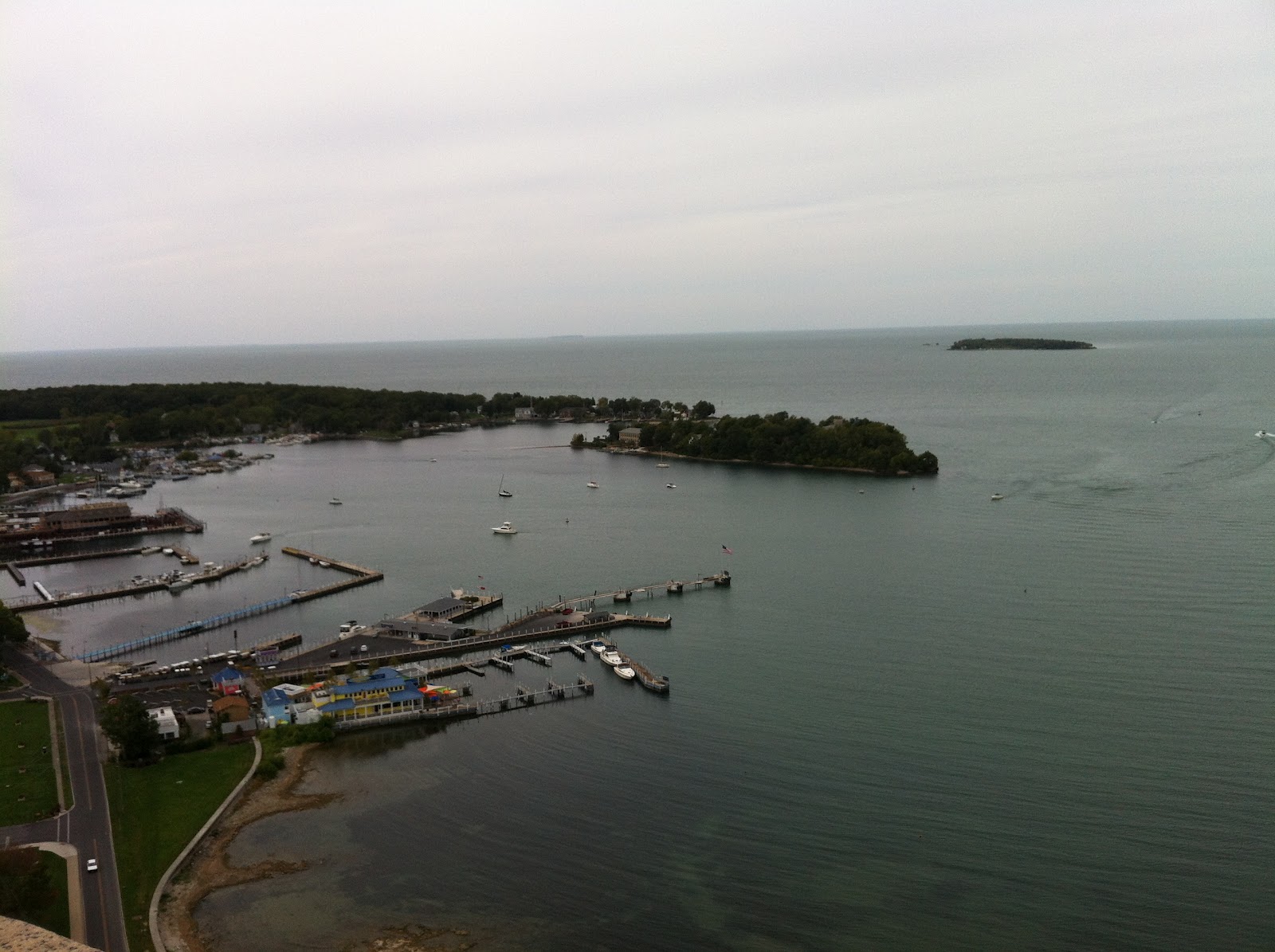 |
| View from the Peace Memorial of Put-in-Bay; Gibraltar Island is in the upper center |
The islands in the middle of the western end of Lake
Erie--Kelly’s, South Bass, and Pelee are the biggest of
many low, rocky outcroppings—provide many ecological and economic benefits. The shallow waters surrounding them are among the most productive in the Great Lakes and
fishing here is part of the culture; neo-tropical warblers and other birds hop across the islands
on their migrations north and south, and birdwatchers from around the world follow them; tourists and vacationers flock to the resorts, docks and open-air bars that are a short ferry ride from the mainland;
and historic and well-visited wineries take advantage of the micro-climate. The principle that our
economy depends on nature is not an intellectual abstraction here.
 Phosphorous, Farming, and Fish. Cool mornings, fresh breezes, and glinting sunlight invigorated those of us on Gibraltar Island, and we (literally) jumped aboard an opportunity to go out on the water on small research vessels to learn about the ecology of Lake Erie. On this day in this year, the story was a good one: while the water clarity measured by a secchi disk was much less than I saw a few weeks ago on a ferry in northern Lake Huron, the sampling we made of the plankton and algae that clouds the water revealed to us the base of the food web that makes the fisheries of western Lake Erie so phenomenal. The quick trawling run we made returned a plethora of fish: walleye, yellow perch, and non-native white perch, but no invasive gobies. One statistic can say much, and the data point of the day was this: while Lake Erie contains only 2 percent of the total water in the Great Lakes, 50 percent of the fish live here.
The biological productivity of Lake Erie extends beyond its shoreline, or really vice-versa. The watershed, which at its western end encompasses northeastern Ohio, southwestern Michigan, and parts of Indiana, contains rich farmland and supports a vital agricultural economy. The Maumee River, the largest single tributary to the Great Lakes, drains this land and its mouth is the active port of Toledo. The organic matter from this watershed transferred into the sun-warmed, shallow waters of western Lake Erie creates a perfect breeding ground for algae, plankton, and other plants that support the insect larvae, small fish, and other creatures that feed the gamefish that end up on the plates of anglers.
 |
| Extent of algae bloom in 2011 in Western Lake Erie (the Detroit River is in upper left) |
 We Have Been Here Before. In 1971, that keen cultural observer Dr. Seuss wrote about the mythical Humming Fish's search for a new clean-water home: “They’ll walk on their fins and get woefully weary in search
of some water that isn’t so smeary.
I hear things are just as bad up in Lake Erie.” In the 1960s, Lake Erie was declared dead as a result of algae blooms, the Cuyahoga River in Cleveland caught fire, and concern for the smallest of Great Lakes helped spur the passage of the Clean Water Act in 1972. The resulting investments in upgraded sewage treatment systems, bans on some detergents and fertilizers, and positive changes in agricultural practices resulted in major declines in phosphorous levels, cleaner water, and a restored Lake Erie. In the 1980s, Dr. Seuss republished "The Lorax," source of the Humming Fish, deleting the above reference. Now, people are quoting the original version again.
We Have Been Here Before. In 1971, that keen cultural observer Dr. Seuss wrote about the mythical Humming Fish's search for a new clean-water home: “They’ll walk on their fins and get woefully weary in search
of some water that isn’t so smeary.
I hear things are just as bad up in Lake Erie.” In the 1960s, Lake Erie was declared dead as a result of algae blooms, the Cuyahoga River in Cleveland caught fire, and concern for the smallest of Great Lakes helped spur the passage of the Clean Water Act in 1972. The resulting investments in upgraded sewage treatment systems, bans on some detergents and fertilizers, and positive changes in agricultural practices resulted in major declines in phosphorous levels, cleaner water, and a restored Lake Erie. In the 1980s, Dr. Seuss republished "The Lorax," source of the Humming Fish, deleting the above reference. Now, people are quoting the original version again.The shallow depth of Lake Erie makes it an ideal environment to grow algae, of both good and bad varieties. The shallow depth also means that the total volume of water in the Lake is less than any other of the Great Lakes, and thus the water in the Lake, which is ever-flowing in from the Detroit River and out over Niagara Falls, turns over in just a few years. The water in low-flow, deep Lake Superior takes several hundred years to be replace. Thus, in the 1970s, the reduction in phosphorous inflows quickly resulted in a clean Lake Erie.
With the hope that reductions in phosphorous and rapid turnover can again help the Lake recover, scientists are looking into the sources and pathways that bring "Big P" into the Lake. What we use to wash our clothes, how we get our lawns green, and how we make our crops grow all effect the amount of phosphorous in the ecosystem. Lots of attention is being paid to agricultural practices: what kinds, and when and how, fertilizer is applied to fields; when plowing does or does not occur; how we drain farmland and design ditches; and the types of crops grown in and out of season; all of these may play a role.
The Nature Conservancy has for several years worked in the upper watershed of the Maumee River to promote agricultural practices that reduce the run-off of fertilizer and sediment; now those efforts are being redoubled and expanded (read more here). Many partners--from local conservation districts and agricultural supply companies to university researchers and advocacy groups on both sides of the border--are all seeking ways to reduce the amount of phosphorous in Lake Erie and thus reduce the algae blooms that threaten to kill the Lake again.
Where is the Coast? Lake Erie's water quality suffers too from the loss of wetlands along its coast and at the mouths of the rivers and creeks that flow into the lake. These areas reduce erosion, slow down water, and allow plant life to absorb phosphorous and other nutrients. Historically, the boundary between land and water in Western Lake Erie has been hard to define, as the shallow waters transitioned into marshes and upland swamps. Over time, the boundary became hardened by dikes and development, coastal wetlands were drained or filled, and waterways dredged. Now, this natural filter has been lost and 95 percent of the native wetland habitat destroyed. Fortunately, public wildlife refuges and private duck hunting clubs saved some important areas (read here about my trip to Erie Marsh).
The Nature Conservancy has set, and moved on, several ambitious goals to restore the coastline of Lake Erie. Already, 2,500 acres of wetlands have been re-established along the western end of the Lake, thanks in part to funding from the Great Lakes Restoration Initiative and other public and private sources. Partnerships with Ducks Unlimited has helped fix and open dike systems so that wetlands have become connected with the flow of the Lake and waterfowl sites created. Working with both public and private landowners, the Conservancy is halfway towards its goal of having 40 percent of the area within one mile of the shore in natural habitat. Finally, land stewards appear to have found ways to get the upper hand on phragmites, the invasive marsh grass that crowds out native plants and animals and retards water flow.
 |
| Scheeff Nature Preserve |
The task before us is twofold. First, we need to transfer the love of place from the specific to the whole landscape. Lake Erie can be saved if we can change policies in two countries, if we can find the will to make large public investments in land and infrastructure, and if we can modify the cultural practices in how we use the land. Second, if we can think about the whole ecosystem that is Lake Erie and celebrate what makes it special, then people from many walks of life will be inspired to take the individual actions necessary to save it.
If you plan to visit. Lake Erie's shores and islands have a robust tourist infrastructure that takes in wildlife enthusiasts, boaters, anglers, and even those looking for a get-away resort or amusement park. A comprehensive website www.shoresandislands.com is a good starting point to plan a visit.
The Ohio Sea Grant program has made available several useful publications about Lake Erie, including "Explore the Lake Erie Islands: A Guide to Nature and History Along the Lake Erie Central Coast Trail" that contains useful background information, maps, and detailed advice on observing the natural history of the area (click here to order or download)
 Thank you to the talented and committed Great Lakes staff of The Nature Conservancy for making this visit to Lake Erie possible. Photo on the left is of TNC's Ohio State Director Josh Knights helping with fish sampling. Thanks too to the Stone Lab staff for their hospittality.
Thank you to Lana Pollack, co-chair of the International Joint Commission, for the Dr. Seuss reference and for her leadership on Lake Erie (read more here).
Tom-
ReplyDeleteThank you for this excellent recap of our time spent at Gibralter Island! I enjoyed the opportunity to visit with you, if only briefly, and look forward to future opportunities to work together.
Regards,
Brett McKamey
Cahpter Chair,
TNC in Indiana
Thanks for the beautiful piece Tom. Informative and inspirational! Jodee Raines, Erb Family Foundation
ReplyDelete